Here are some deeds which record the transfer of property to or from our ancestors in Miami county, Ohio. Click on the rightmost column to see a transcription of the deed which was done by ourselves or by one of our researcher cousins. Kelly Conrad has been especially helpful in locating and deciphering many of these very old documents on microfilm.
| Year | Book/Page | From | To | Township | Section/Township/Range |
|---|---|---|---|---|---|
| 1812 | 02 084 | U. S. A. | David Clark | Staunton | 14 01 11 |
| 1813 | 02 035 | David Clark | Lewis Winans | Staunton | 14 01 11 |
| 1825 | 05 384 | David Clark | George Cary | Staunton | 14 01 11 |
| 1826 | 05 586 | David Clark | Benjamin Cary | Staunton | 04 01 11 |
| 1827 | 06 269 | Thomas Cary | David Cary | Staunton | 14 01 11 |
| 1827 | 06 280 | Zephaniah B. Tenery | Benjamin Cary | Concord | [Troy lot] |
| 1827 | 06 472 | David Carey | Thomas Carey | Spring Creek | 02 01 12 |
| 1830 | 08 209 | John Carey | Thomas Watkins | Monroe | 23 04 06 1 |
| 1831 | 09 023 | Jonathan Rollins | Joseph Layton | Staunton | 02 01 11 |
| 1849 | 25 227 | David Carey | Michael Miller | Staunton | 14 01 11 |
| 1850 | 27 007 | J. Augustus Root | John Perry | Washington | [Piqua lot] |
| 1850 | 27 492 | George Carey | Michael Miller | Staunton | 14 01 11 |
| 1858 | 35 253 | Elizabeth Webber | Michael Miller | Staunton | 14 01 11 |
In these transcriptions, we've highlighted in bold type the names of people or places of interest, and added punctuation and line breaks to make the documents more readable. These documents should be considered under construction for a while as work goes on reformatting them and identifying the people mentioned, and the significance of the transactions occurring when and where they did.
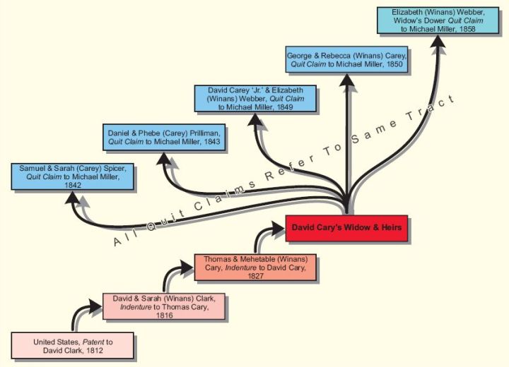
Kelly prepared the following chart to illustrate the transactions by which the same tract in Section 14 Township 01 Range 11 was transferred between various family members. To see a transaction, if it is available, please click on the box describing it:

Another of Kelly's charts shows the exact locations within Section 14 of the various tracts which were transferred. (You must have Adobe Reader installed on your computer to view this chart.)
In addition to locating the deeds which document our ancestors' land holdings and preparing these helpful charts, Kelly has also written a lengthy article discussing the survey system used "between the Miamis" and comparing it to other early systems. Don't miss it!